|
TANZANIA - LINDI REGION
Districts in Lindi Region
 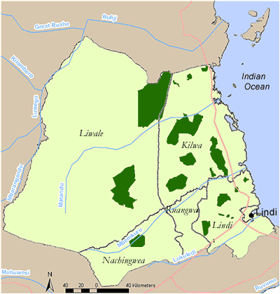
Click on a District on the map, or follow the text links below.
Kilwa
Lindi
Liwale
Nachingwea
Kilwa District
In the Kilwa District there are 15 coastal forested areas profiled. These are listed below:
There is one Important Bird Area in Kilwa District which includes Pindiro (including forest north west of the reserve), Ngarama, Mitundumbea (including forest north west of the reserve), Mbinga, Tong’omba and Kitope forest reserves (TZ IBA 50). The coastal forests in the south of Kilwa District including Ngarama, Mitundumbea and Pindiro fall within the ‘Lindi local centre of endemism’. The northern forests including Mbinga, Nang’oma, Kitope and Tong’omba together with the Kichi Hills in Rufiji District are considered a ‘minor centre of endemism’.
Conservation Initiatives have been supported in the area by World Wide Fund for Nature in focal project sites (in and around Mbinga and Tong’omba Forest Reserves). UTUMI were active in raising awareness of the value of the resources in Kitope Forest Reserve, which is now part of the District’s PFM programme. The Mpingo Conservation Project has been conducting research and community based conservation in the District since 1995, focusing on the valuable timber Dalbergia melanoxylon.
Key Economic and hydrological values: Since the opening of the Mkapa Bridge over the Rufiji River in 2003, economic activity has increased, particularly logging and charcoal production. Logging is a particular threat in areas such as Mitundumbea, Ngarama North and Mbarawala where there are still sizeable timber trees, especially along water courses. Mitundumbea Forest Reserve and the Mbarawala Plateau forest are important for protecting the catchment of the Mavuji River, which supplies two villages with water and supports prawn breeding grounds. Poaching of elephant and other large mammals is also a problem in these areas, especially in the dry season when many animals rely on the Mavuji River. In the north of the District there is ongoing forest clearance for subsistence maize cultivation, which threatens all of the north’s coastal forest patches.
Back to Region index
Kilwa - Proposed Kikole Village Forest Reserve
Reserve name: Proposed Kikole Village Forest Reserve (just north of Mitaurure FR)
Description: Mixed woodland and mixed scrub forest at 110 m asl
Location: 8° 50’ S; 39° 00’ E
Closest settlements: Unknown
Area: Unknown
More details
Threats: Unknown
Conservation initiatives: The first proposed Kikole Village Forest Reserve was found to overlap with Mitaurure Forest Reserve. A revised plan includes an alternative site and was due to be established in 2006 with support from the Mpingo Project.
Conservation designations:
References: Ornis Consult (2002). UTUMI Biodiversity surveys, Tanzania. Report for Ministry of Foreign Affairs and DANIDA, Copenhagen, Denmark.
Back to District index | Back to Region index
Kilwa - Proposed Kisangi Village Forest Reserve
Reserve name: Proposed Kisangi Village Forest Reserve
Description: A combination of miombo and dry mixed forest.
Location: Unknown
Closest settlements: Unknown
Area: 310 ha
More details
Threats: Unknown
Conservation initiatives:
Conservation designations: Part of Kilwa District Coastal Forests IBA 50.
References: Baker, N.E. and Baker, E. M. (2002). Important Bird Areas in Tanzania: A first inventory. Wildlife Conservation Society of Tanzania, Dar es Salaam, Tanzania
Back to District index | Back to Region index
Kilwa - Kitope Forest Reserve
Reserve name: Kitope Forest Reserve
Description: Mixed scrub forest, mixed dry forest and riverine forest between 100 - 230 m asl
Location: 8° 20’ S; 39° 10’ E
Closest settlements: Unknown
Area: 3400 ha
More details
Threats: Timber, fire, cultivation
Conservation initiatives: Conservation initiatives supported by Wildlife Conservation Society of Tanzania. Participatory forest management has been supported in this area through the District Council with support from the DANIDA-financed PFM programme.
Conservation designations: Part of Kilwa District Coastal Forests IBA 50. Protective Forest Reserve.
References: Baker, N.E. and Baker, E. M. (2002). Important Bird Areas in Tanzania: A first inventory. Wildlife Conservation Society of Tanzania, Dar es Salaam, Tanzania
Burgess, N. (2004). Coastal Forest sites table, May 2004. Document prepared for WWF East African Coastal Forest Ecoregion Programme, Nairobi, Kenya.
Clarke, G.P. (1995). Status reports for 6 Coastal Forests in Lindi Region, Tanzania. Frontier-Tanzania Technical Report No. 18. The Society for Environmental Exploration, U.K. / The University of Dar es Salaam, Tanzania
Back to District index | Back to Region index
Kilwa - Mbarawala Plateau
Reserve name: Mbarawala Plateau (also called Mbalawala on some maps, in the literature and by local people). The name is also used to refer to an area further south near Pindiro Forest Reserve.
Description: Coastal dry forest, dry mixed forest, evergreen forest, coastal Brachystegia forest, riverine/groundwater/swamp forest and coastal scrub forest on a dissected plateau of 200 km2 between 150-400m asl. ‘Probably the largest groundwater forest in the Lindi Region’ (Ornis Consult, 2002)
Location: 9 ° 02’-9 ° 09S; 39 ° 05-39 ° 15E
Closest settlements: Migeregere, Nainokwe, Liwiti, Mchakama
Area: estimated 100km 2 of coastal forest.
More details
Threats: timber extraction, poaching, fire
Conservation initiatives: Public lands, no current protection. Possible Local Authority Forest Reserve (LAFR) if funding can be identified. Botanical surveys conducted in 2004 by William Kindeketa of the Tanzania Botanical Research Programme. Mammal survey conducted by Sanne van Aarst also in 2004.
Conservation designations:
References: Ornis Consult (2002). UTUMI Biodiversity surveys, Tanzania. Report for Ministry of Foreign Affairs and DANIDA, Copenhagen, Denmark.,
Msuya , CAet al. (2004) Biological Diversity Survey of the Mbarawala and Ruawa-Likonde Plateaus in Lindi Region Tanzania. Report to The Royal Danish Embassy, Dar es Salaam.
Back to District index | Back to Region index
Kilwa - Mbinga Forest Reserve
Reserve name: Mbinga Forest Reserve
Description: Miombo woodland, thicket tangle, evergreen forest, riverine forest and dry lowland forest between 1600 - 1950 m asl
Location: 8° 32’ S - 8° 29’ S; 38° 47’ E - 38° 52’ E
Closest settlements: Unknown
Area: 1874 ha
More details
Threats: Timber extraction, pole cutting, charcoal production
Conservation initiatives: Focal project site for World Wildlife Fund for Nature Coastal Forest Programme.
Conservation designations: Part of Kilwa District Coastal Forests IBA 50. Part of a “sub-centre of endemism within the eastern African Coastal Forests of Kenya and Tanzania” together with the Kichi Hills. Protective Forest Reserve under central government control.
References: Baker, N.E. and Baker, E. M. (2002). Important Bird Areas in Tanzania: A first inventory. Wildlife Conservation Society of Tanzania, Dar es Salaam, Tanzania
Clarke, G.P. (1995). Status reports for 6 Coastal Forests in Lindi Region, Tanzania. Frontier-Tanzania Technical Report No. 18. The Society for Environmental Exploration, U.K. / The University of Dar es Salaam, Tanzania
Critical Ecosystem Partnership Fund (CEPF) (2005). Eastern Arc Mountains and Coastal Forests of Tanzania and Kenya. Ecosystem Profile (updated in March 2005). (pdf)
Ornis Consult (2002). UTUMI Biodiversity surveys, Tanzania. Report for Ministry of Foreign Affairs and DANIDA, Copenhagen, Denmark..
Waters, T.M. and Burgess, N.D. (1994). Preliminary results of biological surveys of Mchungu and Kiwengoma (Matumbi) forests and short visits to seven other forested sites in coastal Tanzania. Frontier Tanzania Report No. 9. The Society for Environmental Exploration, U.K. / The University of Dar es Salaam, Tanzania. 45pp.
Back to District index | Back to Region index
Kilwa - Mitarure Forest Reserve
Reserve name: Mitarure Forest Reserve (also known as Mitaurure)
Description: Miombo woodland with coastal thicket.
Location: 8° 50’ S - 9° 06’ S; 39° 00’ E
Closest settlements: Mbate hamlet (status of hamlet current under negotiation), Ngea, Kipindimbi, Naking’ombe, Nainokwe
Area: 60 484 ha
More details
Threats: Timber extraction, mostly Pterocarpus angolensis and Dalbergia melanoxylon
Conservation initiatives:
Conservation designations: Productive Forest Reserve
References: Clarke, G.P. (1995). Status reports for 6 Coastal Forests in Lindi Region, Tanzania. Frontier-Tanzania Technical Report No. 18. The Society for Environmental Exploration, U.K. / The University of Dar es Salaam, Tanzania
Gregory, A-M, Ball, SMJ, Eziefula UE (1999) Full Report of Tanzanian Mpingo 98. Mpingo Conservation Project, Tanzania.
Back to District index | Back to Region index
Kilwa - Mitundumbea Forest Reserve
Reserve name: Mitundumbea Forest Reserve
Description: Miombo woodland, mixed dry forest, legume-dominated dry forest and mixed scrub forest with thicket between 100 - 650 m asl
Location: 9° 10’ S; 39° 15’ E
Closest settlements: Mchakama
Area: 8547 ha
More details
Threats: Timber extraction, hunting
Conservation initiatives:
Conservation designations: Part of Kilwa District Coastal Forests IBA 50
References: Baker, N.E. and Baker, E. M. (2002). Important Bird Areas in Tanzania: A first inventory. Wildlife Conservation Society of Tanzania, Dar es Salaam, Tanzania
Clarke, G.P. (1995). Status reports for 6 Coastal Forests in Lindi Region, Tanzania. Frontier-Tanzania Technical Report No. 18. The Society for Environmental Exploration, U.K. / The University of Dar es Salaam, Tanzania
Critical Ecosystem Partnership Fund (CEPF) (2005). Eastern Arc Mountains and Coastal Forests of Tanzania and Kenya. Ecosystem Profile (updated in March 2005). (pdf)
Ornis Consult (2002). UTUMI Biodiversity surveys, Tanzania. Report for Ministry of Foreign Affairs and DANIDA, Copenhagen, Denmark..
Back to District index | Back to Region index
Kilwa - Ngarama North Forest Reserve
Reserve name: Ngarama North Forest Reserve
Description: Lowland forest, riverine forest and scrub forest plus much miombo and thicket between 45 - 540 m asl
Location: 9° 15’ S - 9° 33’ S; 39° 15’ E - 39° 27’ E
Closest settlements: Hoteli Tatu, Mandawa, Mtandi, Kiranjeranje
Area: 39628 ha
More details
Threats: Fire, logging, poaching. Pressure on this forest is considered to be high.
Conservation initiatives: Focal project site for World Wildlife Fund for Nature Coastal Forest Programme. Protective Forest Reserve under central government control.
Conservation designations: Part of Kilwa District Coastal Forests IBA 50
References: Baker, N.E. and Baker, E. M. (2002). Important Bird Areas in Tanzania: A first inventory. Wildlife Conservation Society of Tanzania, Dar es Salaam, Tanzania
Clarke, G.P. (1995). Status reports for 6 Coastal Forests in Lindi Region, Tanzania. Frontier-Tanzania Technical Report No. 18. The Society for Environmental Exploration, U.K. / The University of Dar es Salaam, Tanzania
Back to District index | Back to Region index
Kilwa - Ngarama South Forest Reserve
Reserve name: Ngarama South Forest Reserve
Description: Lowland forest and scrub forest between 45 – 540 m asl. However there are undocumented reports that much of the lowland forest has been lost.
Location: 9° 31’ S - 9° 33’ S; 39° 23’ E - 39° 26’ E
Closest settlements: Kiranjeranje and Mkangaga village (Kikundi sub-village)
Area: 2070 ha
More details
Threats: Fire, logging, hunting, shifting cultivation.
Conservation initiatives:
Conservation designations: Kilwa District Coastal Forests IBA 50, Protective Forest Reserve under central government control.
References: Baker, N.E. and Baker, E. M. (2002). Important Bird Areas in Tanzania: A first inventory. Wildlife Conservation Society of Tanzania, Dar es Salaam, Tanzania
Clarke, G.P. (1995). Status reports for 6 Coastal Forests in Lindi Region, Tanzania. Frontier-Tanzania Technical Report No. 18. The Society for Environmental Exploration, U.K. / The University of Dar es Salaam, Tanzania
Critical Ecosystem Partnership Fund (CEPF) (2005). Eastern Arc Mountains and Coastal Forests of Tanzania and Kenya. Ecosystem Profile (updated in March 2005). (pdf)
Ornis Consult (2002). UTUMI Biodiversity surveys, Tanzania. Report for Ministry of Foreign Affairs and DANIDA, Copenhagen, Denmark..
Back to District index | Back to Region index
Kilwa - Nang’oma Caves
Reserve name: Nang’oma Caves (contiguous or may be within Mbinga FR)
Description: Evergreen closed canopy forest with previous cultivation at 500 m asl
Location: 8° 30’ S; 38° 52’ E
Closest settlements: Nandembo
Area: Unknown
More details
Threats: Shifting cultivation
Conservation initiatives:
Conservation designations: national antiquities site
References: Burgess, N. (2004). Coastal Forest sites table, May 2004. Document prepared for WWF East African Coastal Forest Ecoregion Programme, Nairobi, Kenya.
Clarke, G.P. (1995). Status reports for 6 Coastal Forests in Lindi Region, Tanzania. Frontier-Tanzania Technical Report No. 18. The Society for Environmental Exploration, U.K. / The University of Dar es Salaam, Tanzania
Back to District index | Back to Region index
Kilwa - Pande Forest
Reserve name: Pande Forest
Description: Evergreen forest on a hill. Much of the surrounding peninsula has been settled for a long time and the natural vegetation has mostly been replaced by mango and cashew nut trees and maize fields.
Location: 09° 17’ S; 39° 28’ E
Closest settlements: Hoteli Tatu, Pande Plot, Malalani (often called Mtandura), Lihimalyao, Kissongo, Mikoma, Namwedo.
Area: 100 ha
More details
Threats: Cultivation, logging
Conservation initiatives: Public lands, no protection
Conservation designations:
References: Burgess, N. (2004). Coastal Forest sites table, May 2004. Document prepared for WWF East African Coastal Forest Ecoregion Programme, Nairobi, Kenya.
Back to District index | Back to Region index
Kilwa - Pindiro Forest Reserve
Reserve name: Pindiro Forest Reserve
Description: Mixed scrub forest, mixed dry forest, legume dominated forest and Eastern African Brachystegia forest with open woodlands between 100 - 300 m asl
Location: 9° 27’ S - 9° 34’ S; 39° 14’ E - 39° 19’ E
Closest settlements: Unknown
Area: 11 795 ha
More details
Threats: Cultivation, pole cutting, hunting
Conservation initiatives: Focal project site for World Wide Fund for Nature Coastal Forest Programme.
Conservation designations: Part of Kilwa District Coastal Forests IBA 50, Protective Forest Reserve under central government control.
References: Baker, N.E. and Baker, E. M. (2002). Important Bird Areas in Tanzania: A first inventory. Wildlife Conservation Society of Tanzania, Dar es Salaam, Tanzania
Clarke, G.P. (1995). Status reports for 6 Coastal Forests in Lindi Region, Tanzania. Frontier-Tanzania Technical Report No. 18. The Society for Environmental Exploration, U.K. / The University of Dar es Salaam, Tanzania
Critical Ecosystem Partnership Fund (CEPF) (2005). Eastern Arc Mountains and Coastal Forests of Tanzania and Kenya. Ecosystem Profile (updated in March 2005). (pdf)
Ornis Consult (2002). UTUMI Biodiversity surveys, Tanzania. Report for Ministry of Foreign Affairs and DANIDA, Copenhagen, Denmark..
Back to District index | Back to Region index
Kilwa - Rondondo-Kilwa Forest Reserve
Reserve name: Rondondo-Kilwa Forest Reserve
Description: The reserve is mentioned by Fottland (1996) but no other information is available.
Location: Unknown
Closest settlements: Unknown
Area: 381 ha
More details
Threats: Unknown
Conservation initiatives:
Conservation designations: Part of Kilwa District Coastal Forests IBA 50
References: Baker, N.E. and Baker, E. M. (2002). Important Bird Areas in Tanzania: A first inventory. Wildlife Conservation Society of Tanzania, Dar es Salaam, Tanzania
Fottland, H. 1996. Tanzania Forest Reserves, Status 1996. Catchment Forestry report 96.8. Division of Forestry and Beekeeping Division, Dar es Salaam.
Back to District index | Back to Region index
Kilwa - Rungo Forest Reserve
Reserve name: Rungo Forest Reserve
Description: Predominantly open woodland between 100 - 540 m asl. There may also be none was recorded during a survey undertaken by the Mpingo Project in 2005.
Location: 9° 30’ S; 39° 00’ E
Closest settlements: Unknown
Area: 22 586 ha
More details
Threats: Unknown
Conservation initiatives:
Conservation designations: Productive Forest Reserve under central government control.
References: Burgess, N. (2004). Coastal Forest sites table, May 2004. Document prepared for WWF East African Coastal Forest Ecoregion Programme, Nairobi, Kenya.
Clarke, G.P. (1995). Status reports for 6 Coastal Forests in Lindi Region, Tanzania. Frontier-Tanzania Technical Report No. 18. The Society for Environmental Exploration, U.K. / The University of Dar es Salaam, Tanzania
Back to District index | Back to Region index
Kilwa - Tong’omba Forest Reserve
Reserve name: Tong’omba Forest Reserve
Description: Dry forest, riverine forest, transition woodland and woodland between 150 - 540 m asl
Location: 8° 24’ S - 8° 28’ S; 38° 58’ E - 39° 02’ E
Closest settlements: Neighbouring villages: Mwenge, Mwangi, Mtende, Hanga, Nakindu and Kibata. (In some references Pungutuni is listed as the nearest village however the villages listed above are closer).
Area: 2509 ha
More details
Threats: Logging particularly of Mvule (Milicia excelsa), shifting cultivation, hunting, pole cutting
Conservation initiatives: Protective Forest Reserve under central government control. Focal project site for World Wildlife Fund for Nature Coastal Forest Programme.
Conservation designations: Part of Kilwa District Coastal Forests IBA 50. Part of a “sub-centre of endemism within the eastern African Coastal Forests of Kenya and Tanzania” together with the Kichi Hills.
References: Baker, N.E. and Baker, E. M. (2002). Important Bird Areas in Tanzania: A first inventory. Wildlife Conservation Society of Tanzania, Dar es Salaam, Tanzania
Clarke, G.P. (1995). Status reports for 6 Coastal Forests in Lindi Region, Tanzania. Frontier-Tanzania Technical Report No. 18. The Society for Environmental Exploration, U.K. / The University of Dar es Salaam, Tanzania
Critical Ecosystem Partnership Fund (CEPF) (2005). Eastern Arc Mountains and Coastal Forests of Tanzania and Kenya. Ecosystem Profile (updated in March 2005). (pdf)
Waters, T.M. and Burgess, N.D. (1994). Preliminary results of biological surveys of Mchungu and Kiwengoma (Matumbi) forests and short visits to seven other forested sites in coastal Tanzania. Frontier Tanzania Report No. 9. The Society for Environmental Exploration, U.K. / The University of Dar es Salaam, Tanzania. 45pp.
Back to District index | Back to Region index
Lindi District
In the Lindi District there are 23 coastal forested areas profiled. These are listed below:
In addition, there are 2 forests within the district that have no available information and are not given as forest profiles:
- Mongo Forest 19 ha
- Mpigamiti Forest 30000 ha
There is one Important Bird Area found in Chitoa, Litipo, Ndimba, Nyangamara, Rondo and Ruawa Forest Reserves (TZ IBA 51)
Conservation Initiatives were supported for a few years by the Wildlife Conservation Society of Tanzania (Chitoa, Litipo and Nyangamara Forest Reserves). The Tanzanian government Rondo Forest Project (1952-1982) worked in Rondo Forest Reserve, mainly on plantation development.
Key Economic and hydrological values: Since the opening of the Mkapa Bridge over the Rufiji River in 2003, economic activity has increased, particularly logging and charcoal production.
Back to Region index
Lindi - Chitoa Forest Reserve
Reserve name: Chitoa Forest Reserve
Description: Scrub forest, dry evergreen forests and woodland between 240 – 420 m asl
Location: 9° 56’ S - 9° 58’ S; 39° 26’ E - 39° 28’ E
Closest settlements: 3 km north of Kinyope and Nampawara villages on main Lindi-Milola road
Area: 7718 ha
More details
Threats: Uncontrolled fires, potential timber extraction
Conservation initiatives: Protective and Productive Forest Reserve under District Authority control. Conservation initiatives were previously supported by the Wildlife Conservation Society of Tanzania
Conservation designations: Part of Lindi District Coastal Forests IBA 51
References: Baker, N.E. and Baker, E. M. (2002). Important Bird Areas in Tanzania: A first inventory. Wildlife Conservation Society of Tanzania, Dar es Salaam, Tanzania
Clarke, G.P. (1995). Status reports for 6 Coastal Forests in Lindi Region, Tanzania. Frontier-Tanzania Technical Report No. 18. The Society for Environmental Exploration, U.K. / The University of Dar es Salaam, Tanzania
Critical Ecosystem Partnership Fund (CEPF) (2005). Eastern Arc Mountains and Coastal Forests of Tanzania and Kenya. Ecosystem Profile (updated in March 2005). (pdf)
Ornis Consult (2002). UTUMI Biodiversity surveys, Tanzania. Report for Ministry of Foreign Affairs and DANIDA, Copenhagen, Denmark.
Back to District index | Back to Region index
Lindi - Kiwawa plateau
Reserve name: Kiwawa plateau
Description: Mosaic of patches of scrub forest and closed canopy Mninga woodland
Location: 09° 46’ S; 39° 16’ E
Closest settlements: Unknown
Area: 100 ha
More details
Threats: Unknown
Conservation initiatives:
Conservation designations: Public lands
References: Burgess, N. (2004). Coastal Forest sites table, May 2004. Document prepared for WWF East African Coastal Forest Ecoregion Programme, Nairobi, Kenya.
Back to District index | Back to Region index
Lindi - Kitunda Forest
Reserve name: Kitunda Forest
Description: Unknown
Location: 10° 05’ S; 39° 48’ E
Closest settlements: Unknown
Area: 237 ha
More details
Threats: Cultivation
Conservation initiatives:
Conservation designations:
References: Burgess, N. (2004). Coastal Forest sites table, May 2004. Document prepared for WWF East African Coastal Forest Ecoregion Programme, Nairobi, Kenya.
Back to District index | Back to Region index
Lindi - Likonde plateau
Reserve name: Likonde plateau
Description: Coastal forest similar to Noto and Rondo Plateaux
Location: 09° 48’ S; 39° 27’ E
Closest settlements: Lindi town
Area: Unknown but100 ha of forest remaining
More details
Threats: Cultivation
Conservation initiatives: Public lands, no protection.
Conservation designations: Part of the Lindi local centre of endemism.
References: Burgess, N. (2004). Coastal Forest sites table, May 2004. Document prepared for WWF East African Coastal Forest Ecoregion Programme, Nairobi, Kenya.
Back to District index | Back to Region index
Lindi - Litipo Forest Reserve
Reserve name: Litipo Forest Reserve
Description: Dry evergreen forest, riverine forests, dry semi-deciduous forest, scrub forest and woodland between 180 - 270 m asl
Location: 10° 01’ S - 10° 03’ S; 39° 28’ E - 39° 31’ E
Closest settlements: 39 km W of Lindi, surrounded by Tandangogoro and Rutamba villages
Area: 996 ha
More details
Threats: Logging, fuelwood collection, hunting
Conservation initiatives: Protective and Productive Forest Reserve under District Authority control. Conservation initiatives were previously supported by the Wildlife Conservation Society of Tanzania
Conservation designations: Part of Lindi District Coastal Forests IBA 51
References: Baker, N.E. and Baker, E. M. (2002). Important Bird Areas in Tanzania: A first inventory. Wildlife Conservation Society of Tanzania, Dar es Salaam, Tanzania
Clarke, G.P. (1995). Status reports for 6 Coastal Forests in Lindi Region, Tanzania. Frontier-Tanzania Technical Report No. 18. The Society for Environmental Exploration, U.K. / The University of Dar es Salaam, Tanzania
Critical Ecosystem Partnership Fund (CEPF) (2005). Eastern Arc Mountains and Coastal Forests of Tanzania and Kenya. Ecosystem Profile (updated in March 2005). (pdf)
Ornis Consult (2002). UTUMI Biodiversity surveys, Tanzania. Report for Ministry of Foreign Affairs and DANIDA, Copenhagen, Denmark.
Back to District index | Back to Region index
Lindi - Liwengula Forest
Reserve name: Liwengula Forest (Reserve cancelled in 1960)
Description: Cashew nut woodland with some forest in the NW corner
Location: 10° 00’ S - 10° 01’ S; 39° 33’ E - 39° 34’ E
Closest settlements: Near to Naitivi coconut plantation
Area: 2983 ha
More details
Threats: Unknown
Conservation initiatives:
Conservation designations:
References: Burgess, N. (2004). Coastal Forest sites table, May 2004. Document prepared for WWF East African Coastal Forest Ecoregion Programme, Nairobi, Kenya.
Clarke, G.P. (1995). Status reports for 6 Coastal Forests in Lindi Region, Tanzania. Frontier-Tanzania Technical Report No. 18. The Society for Environmental Exploration, U.K. / The University of Dar es Salaam, Tanzania
Back to District index | Back to Region index
Lindi - Makangala Forest
Reserve name: Makangala Forest
Description: Miombo woodland with patches of thicket
Location: 9° 59’ S - 10° 01’ S; 39° 20’ E - 39° 25’ E
Closest settlements: Neighbouring villages: Milola and Rutamba
Area: 1271 ha
More details
Threats: Unknown
Conservation initiatives:
Conservation designations:
References: Clarke, G.P. (1995). Status reports for 6 Coastal Forests in Lindi Region, Tanzania. Frontier-Tanzania Technical Report No. 18. The Society for Environmental Exploration, U.K. / The University of Dar es Salaam, Tanzania
Back to District index | Back to Region index
Lindi - Matepwa Forest and Tendaguru Hill
Reserve name: Matepwa Forest and Tendaguru Hill
Description: Riverine forest and Dalbergia melanoxylon wooded grassland
Location: 9° 38’ S - 9° 47’ S; 39° 13’ E - 39° 24’ E
Closest settlements: Unknown
Area: >16 493 ha
More details
Threats: Unknown
Conservation initiatives:
Conservation designations:
References: Burgess, N. (2004). Coastal Forest sites table, May 2004. Document prepared for WWF East African Coastal Forest Ecoregion Programme, Nairobi, Kenya.
Clarke, G.P. (1995). Status reports for 6 Coastal Forests in Lindi Region, Tanzania. Frontier-Tanzania Technical Report No. 18. The Society for Environmental Exploration, U.K. / The University of Dar es Salaam, Tanzania
Back to District index | Back to Region index
Lindi - Mchinga Mbili and surrounding forests
Reserve name: Mchinga Mbili and surrounding forests
Description: Dry forests dominanted by Cynometra filifera and Scorodophloeus fischeri
Location: 09° 41’ S; 39° 43’ E
Closest settlements: Unknown
Area: >16500 ha
More details
Threats: Unknown
Conservation initiatives:
Conservation designations: Public lands
References: Burgess, N. (2004). Coastal Forest sites table, May 2004. Document prepared for WWF East African Coastal Forest Ecoregion Programme, Nairobi, Kenya.
Back to District index | Back to Region index
Lindi - Mnacho Forest
Reserve name: Mnacho Forest
Description: Thicket, plantation forest for fuelwood (Cassia siamea)
Location: 10° 75’ S; 39° 12’ E
Closest settlements: Unknown
Area: 1129 ha
More details
Threats: Timber extraction
Conservation initiatives: Proposed Local Authority Forest Reserve
Conservation designations:
References: Burgess, N. (2004). Coastal Forest sites table, May 2004. Document prepared for WWF East African Coastal Forest Ecoregion Programme, Nairobi, Kenya.
Clarke, G.P. (1995). Status reports for 6 Coastal Forests in Lindi Region, Tanzania. Frontier-Tanzania Technical Report No. 18. The Society for Environmental Exploration, U.K. / The University of Dar es Salaam, Tanzania
Back to District index | Back to Region index
Lindi - Mtama Forest Reserve
Reserve name: Mtama Forest Reserve
Description: Woodland
Location: 10° 19’ S; 39° 17’ E
Closest settlements: 2 km north of Nyangao
Area: Unknown
More details
Threats: Cultivation
Conservation initiatives:
Conservation designations:
References: Clarke, G.P. (1995). Status reports for 6 Coastal Forests in Lindi Region, Tanzania. Frontier-Tanzania Technical Report No. 18. The Society for Environmental Exploration, U.K. / The University of Dar es Salaam, Tanzania
Back to District index | Back to Region index
Lindi - Namikupula Forest
Reserve name: Namikupula Forest
Description: Unknown
Location: 10° 52’ S; 39° 55’ E
Closest settlements: Unknown
Area: Unknown
More details
Threats: Unknown
Conservation initiatives: Public lands, no protection
Conservation designations:
References: Burgess, N. (2004). Coastal Forest sites table, May 2004. Document prepared for WWF East African Coastal Forest Ecoregion Programme, Nairobi, Kenya.
Back to District index | Back to Region index
Lindi - Nandimba Forest
Reserve name: Nandimba Forest
Description: Unknown
Location: 9° 57’ S; 39° 06’ E
Closest settlements: Mandawa village
Area: 1250 ha
More details
Threats: Unknown
Conservation initiatives: Degazetted from Forest Reserve, no protection
Conservation designations:
References: Burgess, N. (2004). Coastal Forest sites table, May 2004. Document prepared for WWF East African Coastal Forest Ecoregion Programme, Nairobi, Kenya.
Clarke, G.P. (1995). Status reports for 6 Coastal Forests in Lindi Region, Tanzania. Frontier-Tanzania Technical Report No. 18. The Society for Environmental Exploration, U.K. / The University of Dar es Salaam, Tanzania
Back to District index | Back to Region index
Lindi - Ndimba Forest Reserve
Reserve name: Ndimba Forest Reserve
Description: Dry forest, thicket and plantation between 75 - 150 m asl
Location: 09° 34’ S - 09° 37’ S; 39° 35’ E - 39° 40’ E
Closest settlements: 0.5 km Kikopo village
Area: 2680 ha
More details
Threats: Extraction of fuelwood, soil erosion, pole cutting
Conservation initiatives: Protective Forest Reserve under District Authority control.
Conservation designations: Part of Lindi District Coastal Forests IBA 51
References: Baker, N.E. and Baker, E. M. (2002). Important Bird Areas in Tanzania: A first inventory. Wildlife Conservation Society of Tanzania, Dar es Salaam, Tanzania
Burgess, N. (2004). Coastal Forest sites table, May 2004. Document prepared for WWF East African Coastal Forest Ecoregion Programme, Nairobi, Kenya.
Clarke, G.P. (1995). Status reports for 6 Coastal Forests in Lindi Region, Tanzania. Frontier-Tanzania Technical Report No. 18. The Society for Environmental Exploration, U.K. / The University of Dar es Salaam, Tanzania
Critical Ecosystem Partnership Fund (CEPF) (2005). Eastern Arc Mountains and Coastal Forests of Tanzania and Kenya. Ecosystem Profile (updated in March 2005). (pdf)
Back to District index | Back to Region index
Lindi - Noto Plateau
Reserve name: Noto Plateau
Description: Evergreen coastal forest, mixed scrub forest and mixed dry forest
Location: 9° 52’ S; 39° 22’ E
Closest settlements: Unknown
Area: ~4500 ha, 1000 ha of forest remaining
More details
Threats: Timber extraction
Conservation initiatives: Public lands, no protection
Conservation designations:
References: Burgess, N. (2004). Coastal Forest sites table, May 2004. Document prepared for WWF East African Coastal Forest Ecoregion Programme, Nairobi, Kenya.
Clarke, G.P. (1995). Status reports for 6 Coastal Forests in Lindi Region, Tanzania. Frontier-Tanzania Technical Report No. 18. The Society for Environmental Exploration, U.K. / The University of Dar es Salaam, Tanzania
Ornis Consult (2002). UTUMI Biodiversity surveys, Tanzania. Report for Ministry of Foreign Affairs and DANIDA, Copenhagen, Denmark.
Back to District index | Back to Region index
Lindi - Nyangadi 1, Nanyalio-Nahungo, Nyenga, Nangiule 2 and Ntatala Forest Reserves
Reserve name: Nyangadi 1, Nanyalio-Nahungo, Nyenga, Nangiule 2 and Ntatala Forest Reserves
Description: Miombo woodland and coastal thicket
Location: Unknown
Closest settlements: Unknown
Area: > 5200 ha (4540 1 ha, 650 2 ha)
More details
Threats: Unknown
Conservation initiatives: Protective Forest Reserve to conserve areas of the Rondo Scarp
Conservation designations:
References: Clarke, G.P. (1995). Status reports for 6 Coastal Forests in Lindi Region, Tanzania. Frontier-Tanzania Technical Report No. 18. The Society for Environmental Exploration, U.K. / The University of Dar es Salaam, Tanzania
Back to District index | Back to Region index
Lindi - Nyangamara Forest Reserve
Reserve name: Nyangamara Forest Reserve
Description: Dry forest and bamboo
Location: 10° 00’ S; 39° 30’ E
Closest settlements: Unknown
Area: 600 ha
More details
Threats: Pole cutting
Conservation initiatives: Proposed Forest Reserve. Conservation initiatives supported by Wildlife Conservation Society of Tanzania.
Conservation designations: Part of Lindi District Coastal Forests IBA 51
References: Baker, N.E. and Baker, E. M. (2002). Important Bird Areas in Tanzania: A first inventory. Wildlife Conservation Society of Tanzania, Dar es Salaam, Tanzania
Burgess, N. (2004). Coastal Forest sites table, May 2004. Document prepared for WWF East African Coastal Forest Ecoregion Programme, Nairobi, Kenya.
Critical Ecosystem Partnership Fund (CEPF) (2005). Eastern Arc Mountains and Coastal Forests of Tanzania and Kenya. Ecosystem Profile (updated in March 2005). (pdf)
Back to District index | Back to Region index
Lindi - Rondo Forest Reserve
Reserve name: Rondo Forest Reserve
Description: Dry evergreen forest, transition woodland, woodland and plantation between 465 - 885 m asl
Location: 10° 04’ S - 10° 14’ S; 39° 08’ E - 39° 15’ E
Closest settlements: 4 km from Ntene Rondo village, 60 km west of Lindi
Area: 14 060 ha
More details
Threats: Shifting cultivation and intensive logging between 1949 - 1985 (Mvule – Milicia excelsa) with small scale pitsawing still occurring, fires, charcoal production, pole cutting
Conservation initiatives: Productive Forest Reserve managed by the Rondo Forest Project. Conservation initiatives supported by Wildlife Conservation Society of Tanzania and World Wildlife Fund for Nature. Rondo Forest Project created plantations of hardwoods and pine from 1952 - 1982, changing to Mvule (Milicia excelsa) and Teak (Tectona grandis) after this time; they have an active forestry operation which has helped to discourage agricultural encroachment.
Conservation designations: Part of Lindi District Coastal Forests IBA 51
References: Baker, N.E. and Baker, E. M. (2002). Important Bird Areas in Tanzania: A first inventory. Wildlife Conservation Society of Tanzania, Dar es Salaam, Tanzania
Clarke, G.P. (1995). Status reports for 6 Coastal Forests in Lindi Region, Tanzania. Frontier-Tanzania Technical Report No. 18. The Society for Environmental Exploration, U.K. / The University of Dar es Salaam, Tanzania
Critical Ecosystem Partnership Fund (CEPF) (2005). Eastern Arc Mountains and Coastal Forests of Tanzania and Kenya. Ecosystem Profile (updated in March 2005). (pdf)
Back to District index | Back to Region index
Lindi - Ruawa Forest Reserve
Reserve name: Ruawa Forest Reserve
Description: Evergreen coastal forest and cultivation between 150 - 460 m asl
Location: 9° 43’ S - 9° 46’ S; 39° 32’ E - 39° 35’ E
Closest settlements: Neighbouring village: Kilangala, Munimbila and Lichuhu
Area: 2949 ha
More details
Threats: Cultivation, logging of Mvule (Milicia excelsa), settlement
Conservation initiatives: Central Government Productive Forest Reserve.
Conservation designations: Part of Lindi District Coastal Forests IBA 51. Part of the Lindi local centre of endemism.
References: Baker, N.E. and Baker, E. M. (2002). Important Bird Areas in Tanzania: A first inventory. Wildlife Conservation Society of Tanzania, Dar es Salaam, Tanzania
Clarke, G.P. (1995). Status reports for 6 Coastal Forests in Lindi Region, Tanzania. Frontier-Tanzania Technical Report No. 18. The Society for Environmental Exploration, U.K. / The University of Dar es Salaam, Tanzania
Critical Ecosystem Partnership Fund (CEPF) (2005). Eastern Arc Mountains and Coastal Forests of Tanzania and Kenya. Ecosystem Profile (updated in March 2005). (pdf)
Back to District index | Back to Region index
Liwale District
In the Liwale District there is one coastal forested area profiled. This is:
There are no Important Bird Areas found in this district.
Conservation Initiatives:
Key economic and hydrological values: Since the opening of the Mkapa Bridge over the Rufiji River in 2003, economic activity has increased, particularly logging and charcoal production. Cashew nut production is a major economic activity in the area.
Back to Region index
Liwale - Nyera Kiperere Forest Reserve
Reserve name: Nyera Kiperere Forest Reserve
Description: Coastal forest
Location: 09° 45’ S; 38° 15’ E
Closest settlements: Unknown
Area: Unknown
More details
Threats: Unknown
Conservation initiatives:
Conservation designations:
References: Burgess, N. (2004). Coastal Forest sites table, May 2004. Document prepared for WWF East African Coastal Forest Ecoregion Programme, Nairobi, Kenya.
Clarke, G.P. (1995). Status reports for 6 Coastal Forests in Lindi Region, Tanzania. Frontier-Tanzania Technical Report No. 18. The Society for Environmental Exploration, U.K. / The University of Dar es Salaam, Tanzania
Back to District index | Back to Region index
Nachingwea District
In the Nachingwea District there is one coastal forested area profiled. This is:
There are no Important Bird Areas found in this district.
Conservation Initiatives:
Key economic and hydrological values: Since the opening of the Mkapa Bridge over the Rufiji River in 2003, economic activity has increased, particularly logging and charcoal production. Cashew nut production is a major economic activity in the area.
Back to Region index
Nachingwea - Lionja Forest Reserve
Reserve name: Lionja Forest Reserve
Description:
Location: 10° 17’ S; 38° 24’ E
Closest settlements: Unknown
Area: Unknown
More details
Threats: Unknown
Conservation initiatives:
Conservation designations:
References: Burgess, N. (2004). Coastal Forest sites table, May 2004. Document prepared for WWF East African Coastal Forest Ecoregion Programme, Nairobi, Kenya.
Clarke, G.P. (1995). Status reports for 6 Coastal Forests in Lindi Region, Tanzania. Frontier-Tanzania Technical Report No. 18. The Society for Environmental Exploration, U.K. / The University of Dar es Salaam, Tanzania
Back to District index | Back to Region index
|