|
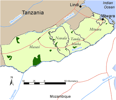
TANZANIA - MTWARA REGION
Districts in Mtwara Region
Click on a District on the map, or follow the text links below.
Mtwara
Newala
Masasi
Tandahimba
Mtwara District
In the Mtwara District there are 3 coastal forested areas. These are listed below:
In addition, there are 2 forests within the district that have no available information and are not given as forest profiles:
- Mamani Forest 757 ha productive
- Naliendele Forest 405 ha productive
There is one Important Bird Area found in Mtiniko Proposed Forest Reserve (TZ IBA 52).
Conservation Initiatives:
Key economic and hydrological values: Since the opening of the Mkapa Bridge over the Rufiji River in 2003, economic activity has increased, particularly logging and charcoal production. Cashew nut production is a major economic activity in the area.
Back to Region index
Mtwara - Mtiniko Proposed Forest Reserve
Reserve name: Mtiniko Proposed Forest Reserve
Description: Mixed dry forest between 170 – 210 m asl
Location: 10° 34’ S - 10° 35’ S; 39° 55’ E - 39° 56’ E
Closest settlements: Neighbouring villages: Mtiniko and Newata
Area: 1736 ha
More details
Threats: Agricultural encroachment, logging and pole cutting
Conservation initiatives: Managed by Central government.
Conservation designations: Part of Mtwara District Coastal Forests IBA 52
References: Baker, N.E. and Baker, E. M. (2002). Important Bird Areas in Tanzania: A first inventory. Wildlife Conservation Society of Tanzania, Dar es Salaam, Tanzania
Frontier-Tanzania (2005). Wegner, G., Howell, K.M., Burgess, N., Rubio, P. and Fanning, E. (Eds.). Reconnaissance Project 2005. The Society for Environmental Exploration and the University of Dar es Salaam; the Critical Ecosystems Partnership Fund
Back to District index | Back to Region index
Mtwara - Mtuli Hinju Proposed Forest Reserve
Reserve name: Mtuli Hinju Proposed Forest Reserve
Description: Legume-dominate dry forest between 215 - 260 m asl
Location: 10° 35’ S; 39° 46’ E - 39° 47’ E
Closest settlements: Neighbouring villages: Mtuli Mjengua and Hinju
Area: 296 ha
More details
Threats: Logging, pole cutting
Conservation initiatives: Managed by Central government.
Conservation designations:
References: Frontier-Tanzania (2005). Wegner, G., Howell, K.M., Burgess, N., Rubio, P. and Fanning, E. (Eds.). Reconnaissance Project 2005. The Society for Environmental Exploration and the University of Dar es Salaam; the Critical Ecosystem Partnership Fund
Back to District index | Back to Region index
Mtwara - Ziwani Forest Reserve
Reserve name: Ziwani Forest Reserve
Description: 50 m asl
Location: 10° 21’ S; 39° 15’ E
Closest settlements: Unknown
Area: 770 ha of forest left
More details
Threats: Unknown
Conservation initiatives:
Conservation designations: Productive forest
References: Burgess, N. (2004). Coastal Forest sites table, May 2004. Document prepared for WWF East African Coastal Forest Ecoregion Programme, Nairobi, Kenya.
Back to District index | Back to Region index
Newala District
In the Newala District there are 4 coastal forested areas profiled. These are listed below:
In addition, there are 2 forests within the district that have no available information and are not given as forest profiles:
- Liteho Forest 1400 ha productive
- Namikupa Forest 1050 ha productive
There is one Important Bird Area found in Makonde Scarp II Proposed Forest Reserve and Mkunya River Proposed Forest Reserve (TZ IBA 53).
Conservation Initiatives:
Key Economic and hydrological values: Since the opening of the Mkapa Bridge over the Rufiji River in 2003, economic activity has increased, particularly logging and charcoal production. Cashew nut production is a major economic activity in the area.
Back to Region index
Newala - Chilangala Forest Reserve
Reserve name: Chilangala Forest Reserve
Description: Unknown
Location: 10° 33’ S; 39° 08’ E
Closest settlements: Unknown
Area: 600 ha
More details
Threats: Unknown
Conservation initiatives:
Conservation designations: Productive forest
References: Burgess, N. (2004). Coastal Forest sites table, May 2004. Document prepared for WWF East African Coastal Forest Ecoregion Programme, Nairobi, Kenya.
Back to District index | Back to Region index
Newala - Mahuta Forest Reserve
Reserve name: Mahuta Forest Reserve
Description: Unknown
Location: 10° 52’ S; 39° 55’ E
Closest settlements: Unknown
Area: 1500 ha
More details
Threats: Unknown
Conservation initiatives:
Conservation designations: Productive forest
References: Burgess, N. (2004). Coastal Forest sites table, May 2004. Document prepared for WWF East African Coastal Forest Ecoregion Programme, Nairobi, Kenya.
Back to District index | Back to Region index
Newala - Makonde Scarp II Proposed Forest Reserve
Reserve name: Makonde Scarp II Proposed Forest Reserve
Description: Brachystegia forest, mixed scrub forest and thicket between 550 - 780 m asl
Location: 10° 50’ S - 10° 52’ S; 39° 10’ E - 39° 14’ E
Closest settlements: Neighbouring villages: Lulindi and Newala town
Area: 1554 ha
More details
Threats: Agricultural encroachment, logging, hunting
Conservation initiatives: Managed by Central Government.
Conservation designations: Part of Newala District Coastal Forests IBA 53
References: Baker, N.E. and Baker, E. M. (2002). Important Bird Areas in Tanzania: A first inventory. Wildlife Conservation Society of Tanzania, Dar es Salaam, Tanzania.
Critical Ecosystem Partnership Fund (CEPF) (2005). Eastern Arc Mountains and Coastal Forests of Tanzania and Kenya. Ecosystem Profile (updated in March 2005). (pdf)
Frontier-Tanzania (2005). Wegner, G., Howell, K.M., Burgess, N., Rubio, P. and Fanning, E. (Eds.). Reconnaissance Project 2005. The Society for Environmental Exploration and the University of Dar es Salaam; the Critical Ecosystem Partnership Fund.
Back to District index | Back to Region index
Newala - Mkunya River Proposed Forest Reserve
Reserve name: Mkunya River Proposed Forest Reserve
Description: Brachystegia forest and riverine forest between 88 - 250 m asl
Location: 10° 52’ S - 11° 02’ S; 39° 13’ E - 39° 27’ E
Closest settlements: Neighbouring villages: Mkunya, Chiunjila, Chikwedu, Mapili, Nanguruwe and Magunchila
Area: 4797 ha
More details
Threats: Agricultural encroachment, logging, fuelwood collection
Conservation initiatives: Managed by Central government.
Conservation designations: Part of Newala District Coastal Forests IBA 53
References: Baker, N.E. and Baker, E. M. (2002). Important Bird Areas in Tanzania: A first inventory. Wildlife Conservation Society of Tanzania, Dar es Salaam, Tanzania
Critical Ecosystem Partnership Fund (CEPF) (2005). Eastern Arc Mountains and Coastal Forests of Tanzania and Kenya. Ecosystem Profile (updated in March 2005). (pdf)
Frontier-Tanzania (2005). Wegner, G., Howell, K.M., Burgess, N., Rubio, P. and Fanning, E. (Eds.). Reconnaissance Project 2005. The Society for Environmental Exploration and the University of Dar es Salaam; the Critical Ecosystems Partnership Fund
Back to District index | Back to Region index
Masasi District
In the Masasi District there are 3 coastal forested areas. These are listed below:
There is one Important Bird Area found in Makonde Scarp I Proposed Forest Reserve (TZ IBA 53).
Conservation Initiatives:
Key Economic and hydrological values: Since the opening of the Mkapa Bridge over the Rufiji River in 2003, economic activity has increased, particularly logging and charcoal production. Cashew nut production is a major economic activity in the area.
Back to Region index
Masasi - Kambona Forest Reserve
Reserve name: Kambona Forest Reserve
Description: Brachystegia forest and riverine forest between 670 - 700 m asl
Location: 10° 37’ S; 39° 01’ E
Closest settlements: 10 km from Masasi town
Area: 29.9 ha
More details
Threats: Logging, fuelwood collection, hunting
Conservation initiatives: Managed by Central Government.
Conservation designations:
References: Frontier-Tanzania (2005). Wegner, G., Howell, K.M., Burgess, N., Rubio, P. and Fanning, E. (Eds.). Reconnaissance Project 2005. The Society for Environmental Exploration and the University of Dar es Salaam; the Critical Ecosystems Partnership Fund
Back to District index | Back to Region index
Masasi - Makonde Scarp I Proposed Forest Reserve
Reserve name: Makonde Scarp I Proposed Forest Reserve
Description: Brachystegia forest between 600 - 640 m asl
Location: 10° 38’ S - 10° 40’ S; 39° 02’ E - 39° 03’ E
Closest settlements: Neighbouring villages: Chidya and Mjembe villages
Area: 1748 ha
More details
Threats: Cultivation, hunting, logging, fuelwood collection
Conservation initiatives: Managed by Central government.
Conservation designations: Part of Newala District Coastal Forests IBA 53
References: Baker, N.E. and Baker, E. M. (2002). Important Bird Areas in Tanzania: A first inventory. Wildlife Conservation Society of Tanzania, Dar es Salaam, Tanzania
Critical Ecosystem Partnership Fund (CEPF) (2005). Eastern Arc Mountains and Coastal Forests of Tanzania and Kenya. Ecosystem Profile (updated in March 2005). (pdf)
Frontier-Tanzania (2005). Wegner, G., Howell, K.M., Burgess, N., Rubio, P. and Fanning, E. (Eds.). Reconnaissance Project 2005. The Society for Environmental Exploration and the University of Dar es Salaam; the Critical Ecosystems Partnership Fund
Back to District index | Back to Region index
Masasi - Ndechela Forest Reserve
Reserve name: Ndechela Forest Reserve
Description: Legume-dominated dry forest between 250 - 340 m asl
Location: 11° 04’ S - 11° 06’ S; 38° 08’ E - 39° 14’ E
Closest settlements: Neighbouring villages: Nakopi and Nihale
Area: 6216 ha
More details
Threats: Fire, logging, hunting
Conservation initiatives: Managed by Central government.
Conservation designations:
References: Frontier-Tanzania (2005). Wegner, G., Howell, K.M., Burgess, N., Rubio, P. and Fanning, E. (Eds.). Reconnaissance Project 2005. The Society for Environmental Exploration and the University of Dar es Salaam; the Critical Ecosystems Partnership Fund
Back to District index | Back to Region index
Tandahimba District
In the Tandahimba District there is one coastal forested area. This is:
There is one Important Bird Area found in Makonde Scarp III Proposed Forest Reserve (TZ IBA 53).
Conservation Initiatives:
Key Economic and hydrological values: Since the opening of the Mkapa Bridge over the Rufiji River in 2003, economic activity has increased, particularly logging and charcoal production. Cashew nut production is a major economic activity in the area.
Back to Region index
Tandahimba - Makonde Scarp III Proposed Forest Reserve
Reserve name: Makonde Scarp III Proposed Forest Reserve
Description: Brachystegia forest and thicket between 340 - 435 m asl
Location: 10° 53’ S - 10° 54’ S; 39° 24’ E - 39° 25’ E
Closest settlements: Neighbouring villages: Lidumbeand Mcholi
Area: 1435 ha
More details
Threats: Agricultural encroachment
Conservation initiatives: Managed by Central government.
Conservation designations: Part of Newala District Coastal Forests IBA 53
References: Baker, N.E. and Baker, E. M. (2002). Important Bird Areas in Tanzania: A first inventory. Wildlife Conservation Society of Tanzania, Dar es Salaam, Tanzania
Critical Ecosystem Partnership Fund (CEPF) (2005). Eastern Arc Mountains and Coastal Forests of Tanzania and Kenya. Ecosystem Profile (updated in March 2005). (pdf)
Frontier-Tanzania (2005). Wegner, G., Howell, K.M., Burgess, N., Rubio, P. and Fanning, E. (Eds.). Reconnaissance Project 2005. The Society for Environmental Exploration and the University of Dar es Salaam; the Critical Ecosystems Partnership Fund
Back to District index | Back to Region index
|