|
TANZANIA - ZANZIBAR ISLANDS
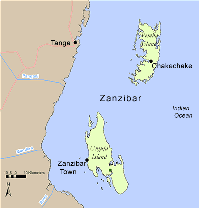
The Zanzibar Islands
Click on the map, or follow the text links below.
Unguja
Pemba
 UNGUJA ISLAND UNGUJA ISLAND
Districts of Unguja Island
Unguja South
Unguja North
Back to Islands index
Unguja South District
In Unguja South District there are two main coastal forested area profiled. These are:
There is one Important Bird Area designated to Jozani (TZ IBA 57).
Conservation Initiatives: CARE International and WCS both have community-based and development projects financed by CEPF in the area surrounding the Jozani-Chwaka Bay National Park.
Key Economic and hydrological values: Tourism is the main economic activity with further production from fisheries and cash crops, such as coconuts, rice and cloves.
Back to Region index | Back to Islands index
Unguja South - Jozani Forest
Reserve name: Jozani Forest
 Description: Groundwater forest, dense evergreen forest and some plantation at 20 m asl Description: Groundwater forest, dense evergreen forest and some plantation at 20 m asl
Location: 06° 12’ S - 06° 20’ S; 39° 24’ E - 39° 40’ E
Closest settlements: Neighbouring villages: Jozani, Kitogani and Kwebona
Area: 1100 ha
More details
Threats: Encroachment, hunting
Conservation initiatives: Originally designated a community supportive Protected Area called the Jozani-Chwaka Bay Conservation Project and now a National Park. Funded with support from Government of Austria and implemented by Zanzibar Commission for Natural Resources with CARE international.
Conservation designations: Part of Tanzania IBA 57
References: Baker, N.E. and Baker, E. M. (2002). Important Bird Areas in Tanzania: A first inventory. Wildlife Conservation Society of Tanzania, Dar es Salaam, Tanzania
Beentje, H.J. (1990). A reconnaissance survey of Zanzibar Forests and Coastal Thicket. Report for the Department of Environment, Commission of Lands and Environment, under the Zanzibar Integrated Land Use Project of FINNIDA. 34pp.
Burgess, N. (2004). Coastal Forest sites table, May 2004. Document prepared for WWF East African Coastal Forest Ecoregion Programme, Nairobi, Kenya.
Critical Ecosystem Partnership Fund (CEPF) (2005). Eastern Arc Mountains and Coastal Forests of Tanzania and Kenya. Ecosystem Profile (updated in March 2005). (pdf)
Back to District index | Back to Region index | Back to Islands index
Unguja South - Muyuni Forest
Reserve name: Muyuni Forest
Description: Evergreen forest and thicket on coral rag at 0 - 20 m asl
Location: 06° 20’ S; 39° 25’ E
Closest settlements: Unknown
Area: 5000 ha
More details
Threats: Fuelwood and farming
Conservation initiatives: None, public lands
Conservation designations:
References: Beentje, H.J. (1990). A reconnaissance survey of Zanzibar Forests and Coastal Thicket. Report for the Department of Environment, Commission of Lands and Environment, under the Zanzibar Integrated Land Use Project of FINNIDA. 34pp.
Burgess, N. (2004). Coastal Forest sites table, May 2004. Document prepared for WWF East African Coastal Forest Ecoregion Programme, Nairobi, Kenya.
Critical Ecosystem Partnership Fund (CEPF) (2005). Eastern Arc Mountains and Coastal Forests of Tanzania and Kenya. Ecosystem Profile (updated in March 2005). (pdf)
Back to District index | Back to Region index | Back to Islands index
Unguja North District
In Unguja North District there are two main coastal forested areas profiled. These are:
There are no Important Bird Areas.
Conservation Initiatives: Community-based forest management initiatives are being proposed in the area (don’t know by whom).
Key Economic and hydrological values: Tourism is the main economic activity with further production from fisheries and cash crops, such as coconuts, rice and cloves.
Back to Region index | Back to Islands index
Unguja North - Kiwengwa Forest
Reserve name: Kiwengwa Forest
Description: Coral rag forest at 0 -20 m asl
Location: 06° 00’ S; 39° 22’ E
Closest settlements: Kiwengwa village
Area: 5000 ha
More details
Threats: Tourism and population increases
Conservation initiatives: Proposed National Park
Conservation designations:
References: Burgess, N. (2004). Coastal Forest sites table, May 2004. Document prepared for WWF East African Coastal Forest Ecoregion Programme, Nairobi, Kenya.
Back to District index | Back to Region index | Back to Islands index
Unguja North - Tumbatu Forest
Reserve name: Tumbatu Forest (Tumbatu island)
Description: Coral rag thicket at 0 -20 m asl
Location: 05° 50’ S - 05° 82’ S; 39° 12’ E - 39° 22’ E
Closest settlements: Unknown
Area: 5000 ha
More details
Threats: Unknown
Conservation initiatives: Proposed community based forest management by ?
Conservation designations:
References: Burgess, N. (2004). Coastal Forest sites table, May 2004. Document prepared for WWF East African Coastal Forest Ecoregion Programme, Nairobi, Kenya.
Critical Ecosystem Partnership Fund (CEPF) (2005). Eastern Arc Mountains and Coastal Forests of Tanzania and Kenya. Ecosystem Profile (updated in March 2005). (pdf)
Back to District index | Back to Region index | Back to Islands index
PEMBA ISLAND
On Pemba Island there is one main coastal forested area profiled. This is:
In addition, there are 2 forests within the district that have no available information and are not given as forest profiles:
This forest has an Important Bird Area designated to it (TZ IBA 76) and Pemba island is an EBA 110.
Conservation Initiatives: The Department of Commercial Crops Fruits and Forestry (DCCFF), CARE Tanzania and FFI are all working together in the area on various biological and community-based initiatives.
Key Economic and hydrological values: Clove plantation is the main economic activity with tourism increasing. Fisheries are also an important livelihood activity on the island.
Back to Islands index
Pemba - Ngezi Forest Reserve
Reserve name: Ngezi Forest Reserve
Description: Coastal evergreen forest, thickets, mangroves, swamps and central heath land at 0 - 20 m asl
Location: 05° 20’ S; 39° 76’ E
Closest settlements: Nearest towns: Konde and Chake Chake
Area: 1440 ha
More details
Threats: Timber extraction, pole cutting, fire wood collection, poaching
Conservation initiatives: Some community-based initiatives in the area by CARE, including participatory forest management and tourism.
Conservation designations: Managed by the Department of Commercial Crops, Fruits and Forests. Part of Tanzania IBA 76 and part of the Pemba Endemic Bird Area (EBA 110).
References: Baker, N.E. and Baker, E. M. (2002). Important Bird Areas in Tanzania: A first inventory. Wildlife Conservation Society of Tanzania, Dar es Salaam, Tanzania
Beentje, H.J. (1990). Botanical Assessment of Ngezi Forest, Pemba. Report prepared for the Zanzibar Forestry Department Project of FINNIDA and the Finnish National Board of Forestry. 45pp.
Critical Ecosystem Partnership Fund (CEPF) (2005). Eastern Arc Mountains and Coastal Forests of Tanzania and Kenya. Ecosystem Profile (updated in March 2005). (pdf)
Back to Region index | Back to Islands index
|